Weather forecast UK LIVE – Britain hit by 20C 'Spanish plume' this weekend bringing 1st taste of summer
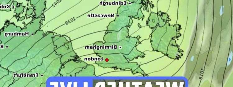
FORECASTERS say a blast of warm air from North Africa is set to hit the UK this weekend bringing temperatures of up to 20C.
Jim Dale, a senior meteorologist at British Weather Services, has said that the UK can expect dry weather and blue skies this weekend, adding temperatures are likely to sit between 17 and 18C, potentially reaching 20C.

The forecaster added that the UK will see "a lot of pleasant weather coming now".
Speaking to Express.co.uk, weather forecaster Phil Morrish also said that: "We're certainly going to get some warmer weather coming in this weekend.
"We'll get temperatures of 15 or 16C.
"As of Saturday, we're going to get what we call a Spanish plume event, where air from North Africa is moving north."
A 'Spanish plume' is a weather event that occurs when a bout of warm air is pushed north from Iberia, and may cause an increased risk of thunderstorms too.
The Met Office has said that the hottest day so far in 2022 was 17.2C in Pershore, Worcestershire.
Read our weather live blog for the latest news and forecasts…
- Milica Cosic
Temperatures of 18C+ this weekend
FORECASTERS say a blast of warm air from North Africa is set to hit the UK this weekend bringing temperatures of up to 18C.
Jim Dale, a senior meteorologist at British Weather Services, has said that the UK can expect dry weather and blue skies this weekend, adding temperatures are likely to sit between 17 and 18C, potentially reaching 20C.
The forecaster added that the UK will see "a lot of pleasant weather coming now".
Speaking to Express.co.uk, weather forecaster Phil Morrish also said that: "We're certainly going to get some warmer weather coming in this weekend.
"We'll get temperatures of 15 or 16C.
"As of Saturday, we're going to get what we call a Spanish plume event, where air from North Africa is moving north."
A 'Spanish plume' is a weather event that occurs when a bout of warm air is pushed north from Iberia, and may cause an increased risk of thunderstorms too.
- Milica Cosic
Good morning, Milica Cosic logging on. I’ll be bringing you the latest news and updates today.
- Joseph Gamp
UK shorelines should expect wet and windy weather
Though most of us will enjoy sunny weather and mild temperatures, it’s not quite the same for our shores.
Strong winds are expected across most coasts, bring with it lots of rain.
The next two days will bring showers to the northeast and gales are likely along with lighter winds at times.
- Joseph Gamp
Explained: Why was the sky orange yesterday?
Hot air in the Sahara desert has lead to dust being dumped across the Mediterranean and now parts of the UK.
It comes as parts of southern Spain have been blanketed following a thick plume which has turned skies orange.
Paris was among the cities in France affected by dust, leaving the city’s 18th arrondissement “covered with a fine layer of orange residue”.
- Joseph Gamp
UK weather outlook for Friday and Saturday
Early patches of mist will soon lift and clear on Friday to leave a fine day as it will be dry with lots of sunshine and just some patchy cloud cover.
On Saturday any early mist and fog will soon clear to leave another fine day as it will be dry with lots of sunshine and blue skies around.
- Joseph Gamp
Short weather summary for today
A fine day as it will be dry with long spells of spring sunshine for most areas although variable amounts of cloud cover will tend to build into northern and western areas.
Outbreaks of rain and scattered showers will spread across Northern Ireland and Scotland and may be locally heavy at times.
- Joseph Gamp
Top tips if storms trigger your asthma
If storms make your asthma worse, then there are things you can do to prevent an attack.
- take your preventer inhaler regularly
- carry your reliever inhaler
- go for regular asthma reviews
- book an extra appointment with your doctor or nurse if you notice you’re using your inhalers more
- try and stay indoors and keep windows and doors closed to avoid letting the dust in
- take usual treatments such as antihistamines
Rules for cyclists looking to enjoy the sunshine this Spring
With the weather set to warm up in the coming weeks, cyclists are ready to get out on their bikes and make the most of the sunshine.
Bobbin Bikes encourage cyclists to make themselves fully aware of what they can and can’t do on the roads.
Road rules for cyclists to stay safe this spring:
- Hand signals – Using hand signals is important for cyclists to communicate their intent to motorists behind them.
- Clothing – Cyclists should always wear a protective helmet that conforms to current regulations, is the correct size, and is securely fastened. Light coloured, fluorescent clothing is best to wear whilst cycling in winter or darker days, and reflective clothing and accessories should be worn in the dark.
- Lights – All cycles must have front, and rear lights lit up at night. All bikes must also be fitted with red rear reflectors.
- Cycle lanes – Dedicated cycle lanes are marked by a white line, which may be solid or broken. Cyclists must stick to cycle lanes when able to.
- Parking – Bicycles must not be left in any place that can cause obstruction or hazard to other road users.
Some rain tday for the west of NI, Highlands, the Western Isles and the Northern Isles
Meteorologist Alex Deakin has brought us the latest weather news for the rest of the day today, reminding us it isn’t sunshine everywhere.
Deakin said there’s a possibility the temperature could get as high as 16C in parts of eastern England today.
He made clear Glasgow and Belfast are likely to experience some showers in the late afternoon leading into the evening, before hitting Edinburgh.
Deakin confirmed Wednesday is looking very cloudy for much of the UK.
- Joseph Gamp
Possible heatwave reaching 28C as early as April
While temperatures are often expected to be mild in April, it’s a month more synonymous with rain.
This year though, according meteorologist, Jim Dale, suggests Brits may experience temperatures at hot as 28C – temperatures typically reserved for the middle of Summer.
Last year’s April barely reached 15C, meanwhile our lockdown April was notoriously scorching.
According to the Met Office, it was the fifth hottest April in the UK since records began in 1929.
- Joseph Gamp
What’s the weather forecast for next week?
With this week looking so lovely for most areas of the UK, we look ahead for much of the same.
Though we’ll likely experience light patches of mist and fog in the early hours of Saturday, it should pass to allow sunshine for the rest of the day throughout most of the UK.
A breeze is possible in most coastal areas, and rain is expected across the northeast.
Though temperatures are expected to be mild to very mild in most areas, there is a chance of overnight frost and fog, throughout the week.
- Joseph Gamp
Mother’s Day weather set to remain dry and sunny
Mother’s Day falls on 27th March this year and doesn’t look like it’ll disappoint.
After Brits took advantage of the mild weather this weekend, we look ahead to more warmth and sunshine.
If you’re looking to enjoy outdoor activities for Mother’s Day, you’ll be in luck as the weather appears to be staying pleasant for the foreseeable future.
- Joseph Gamp
Thanks for reading
Joe Gamp here, signing off from our live UK weather coverage.
We hope you've enjoyed reading our rolling news blog today.
My colleague Milica Cosic returns at 6am.
- Joseph Gamp
In pictures: Saharan dust cloud turns skies orange over Canary Wharf, London
Canary Wharf was visible through orange hues today.
The colour was caused by a dust cloud from the Sahara regions, which hung 2km above ground level across Europe.
Hot air in the Sahara desert led to dust being dumped across the Mediterranean and now parts of the UK.

NINTCHDBPICT000719328693Credit: Alamy - Joseph Gamp
5 day flood forecast
Local flooding is possible but not expected from rivers and surface water.
Land, roads and some properties may flood and there may be travel disruption.
There are around 3,500 measuring stations and most are along main rivers and the coast.
Find a river, sea, groundwater or rainfall level here.
- Joseph Gamp
Brits' photos from today's Saharan dust sky
- Joseph Gamp
UK shorelines should expect wet and windy weather
Though most of us will enjoy sunny weather and mild temperatures, it’s not quite the same for our shores.
Strong winds are expected across most coasts, bring with it lots of rain.
The next two days will bring showers to the northeast and gales are likely along with lighter winds at times.
- Joseph Gamp
Why was the sky orange today?
Hot air in the Sahara desert has lead to dust being dumped across the Mediterranean and now parts of the UK.
It comes as parts of southern Spain have been blanketed following a thick plume which has turned skies orange.
Paris was among the cities in France affected by dust, leaving the city’s 18th arrondissement “covered with a fine layer of orange residue”.
- Joseph Gamp
No air-quality warnings in force today, says Met Office
UK forecasts predicted the dust would most likely be mostly visible at sunset, although particles have already began to pour from the sky.
Met Office meteorologist Richard Miles told the PA News Agency: "Storm Celia over Spain is indeed pulling a dust cloud up from the Sahara, which could potentially reach as far as the south of the UK.
"However, we don’t expect significant impacts – the most likely would be on the cloudscapes at sunset but, as conditions are likely to be generally overcast and wet for much of the day, this is unlikely to amount to much.
"There are no air-quality warnings," he said.
"People in the south might find a bit of dust left on their cars as the rain washes it out of the skies today."
- Joseph Gamp
Clear skies for many this evening
The MEt Office says the band of rain and wind is pushing away.
It will leave skies clear overnight- but means temperatures will feel even more chilly.
The warnings come as the weather is predicted to heat up from tomorrow, with highs of around 16C/17C expected.
- Joseph Gamp
Why is the sky yellow and the sun red?
According to the Met Office, sunsets are often red or orange because they are lower in the sky, therefore sunlight must travel through a thicker layer of the atmosphere before it is scattered, deflected, and seen by the human eye.
This means there is more yellow and red left to see.
In the case of Storm Celia, strong winds carried dust over to Spain from the Sahara desert, causing reduced visibility and orange tones in the sky.
Red dust can have an adverse impact on health, leading to respiratory and cardiac issues if inhaled – and can be especially harmful to people with asthma.
- Joseph Gamp
How did Hurricane Ophelia cause the sky to turn yellow?
Back in October 2017, the sky in Britain similarly turned yellow and the sun turned red as a result of Hurricane Ophelia.
The deadly storm killed three people when it pulled Saharan dust up to the UK, creating a blanket of orange cloud with its deadly 80mph winds
Hurricane Ophelia created an eerie glow, red sun, and left a thick layer of dust behind it.
The storm led to fears of an apocalypse, and widespread health concerns for those with breathing difficulties and the elderly.
At the time, Met Office forecaster Grahame Madge said: “It’s all connected with Ophelia, on the eastern side of the low pressure system air is coming up in the southern direction.
“Air is being pulled from southern Europe and Africa and that air contains a lot of dust.
“So it’s most likely the appearance of sunset at midday is caused by the particles scattering the light and giving the appearance of a red sun.”
In the UK, up to 120,000 homes were without power, schools were closed, and bridges were shut as a result of falling trees and debris caused by Hurricane Ophelia.
- Joseph Gamp
Weather outlook for Friday to Sunday
Showers in the far north clear early Friday.
Some night frost and fog elsewhere, but then all areas dry and increasingly sunny.
Perhaps cloudier with a few showers Sunday.
- Joseph Gamp
Met Office promises plenty of spring sunshine this weekend
It may be a damp and wet day for many across the UK, but things will look a lot brighter on the weekend.
The Met Office tweeted: "Looking ahead to the weekend?
"There will be plenty of warm spring sunshine, especially on Saturday."
- Joseph Gamp
'No significant impacts from Storm Celia dust cloud' says Met Office
Met Office meteorologist Richard Miles told the PA News Agency: "Storm Celia over Spain is indeed pulling a dust cloud up from the Sahara, which could potentially reach as far as the south of the UK.
"However, we don’t expect significant impacts – the most likely would be on the cloudscapes at sunset but, as conditions are likely to be generally overcast and wet for much of the day, this is unlikely to amount to much.
"There are no air-quality warnings," he said.
"People in the south might find a bit of dust left on their cars as the rain washes it out of the skies today."
Source: Read Full Article
