UK weather forecast: Arctic storm to blitz Britain with heavy snow and 90km gales – maps
BBC Weather forecasts falling temperatures across UK
We use your sign-up to provide content in ways you’ve consented to and to improve our understanding of you. This may include adverts from us and 3rd parties based on our understanding. You can unsubscribe at any time. More info
Maps and charts show freezing weather causing havoc across England, with next week ending with heavy rains and winds. Experts have explained a Polar blitz will clash with a storm developing over northern Spain, which will push up throughout Britain by the end of next week.

WXCharts maps show that despite mild conditions for much of November, Monday will see temperatures drop to a chilly 0C (32F) in some parts of Wales and northern Britain, with London seeing 5C (41F).
The colder temperatures are set to last through to Friday, as pressure systems cause havoc over Britain from Tuesday night.
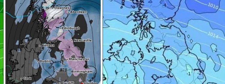
Maps show that from midnight on Wednesday, November 24, fronts of 1mm an hour rain and 1cm an hour snow will begin to push from the north sea over Scotland and northern England.
By 6pm on Wednesday, 2cm of snow will have settled as far as Manchester, and north Wales, while the north coast sees snowfall last throughout the day.


Conditions are expected to turn more stormy overnight on Thursday November 25, as Scotland and Newcastle get buffeted with up to 5cm of snow an hour by 6am and as 2mm of rain an hour soaks Northern Ireland.
A wet front will then push eastwards from the midlands throughout Thursday, with winds beginning to gust at 62km/h overnight.
Friday sees the worst conditions with 89km/h guys along the north west coast by midday.
By midday, 2mm of rain will be falling across much of Britain. with 5mm downpours over Lerwick and 3cm snowfall over Inverness and other parts of north Scotland.
The wet, windy and snowy conditions, according to WXCharts, are expected to last throughout the end of the week, and should give way to only snowfall by Sunday November 28.


Alyssa Smithmyer, Meteorologist at AccuWeather, told Express.co.uk: “Model guidance shows a storm developing south of the United Kingdom early next week, particularly around northern Spain and the Bay of Biscay.
“However, there are a few scenarios currently competing that can either result in this storm shifting northeastward across areas of northern Europe or can bring it along a more southerly track into the Alps.
“If the storm takes more of a northerly track across areas of northern Europe, the entire United Kingdom will likely see an uptick in rainfall by Wednesday, November 24.
“If the storm takes more of a southerly track across the Alps, then southern regions of the UK will likely see more of a dry pattern around midweek and the rainfall activity would likely be across northern regions by Wednesday.”


Ms Smithmyer continued to say: “Aside from the development of this storm south of the UK, we are watching a separate feature that is expected to impact areas of Norway next week may also play a role in the weather across the UK.
“Originating from the north and bringing cooler air with it, this storm has the potential to bring a few flurries to the cooler higher ground across the northern UK late next week.
“Since it is still over a week away, a mix of rain and snow across the lower levels cannot be ruled out for late next week.”


The wintery conditions lead to higher chance of snow, with the Met Office predicting parts of Scotland and northern England may see some fall.
Temperatures could drop to 0C (32F) in some parts of the country from Sunday into the beginning of next week.
In their outlook from November 22 to December 1, the forecaster said: “High pressure will often lie close to western or southwestern parts of the UK during this period.
“This will tend to bring to a colder than average north or northwesterly airflow for a time. The most unsettled conditions will likely be across northern areas.
“Here, showers or longer spells of rain are likely with snow likely across higher ground and possibly falling to low levels at times. Strong winds are possible across the north, especially around coasts.
“Further south, it is likely to remain somewhat drier with fewer showers, but there is even a slight chance of some wintry weather here.
“At points when winds ease any clearer and calmer conditions that prevail will lead to some cold nights with frost and fog.”
Source: Read Full Article