Met Office weather warnings UPDATED: Torrential downpours and lightning to hit UK – maps
UK Weather: Met Office predicts thunderstorms and rain
We use your sign-up to provide content in ways you’ve consented to and to improve our understanding of you. This may include adverts from us and 3rd parties based on our understanding. You can unsubscribe at any time. More info
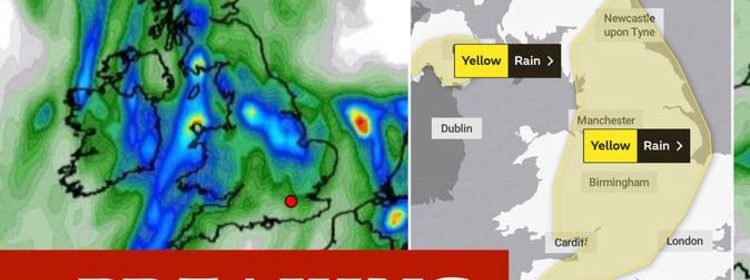
The Met Office has changed and extended several severe weather warnings for rain and thunderstorms this weekend. The forecaster said the focus has now been changed to emphasise the likelihood of torrential downpours as the main hazard with thunderstorms likely to impact several regions.

The Met Office has two weather warnings for rain in effect across the weekend.
The first is in force across much of the UK from midday until 11.59pm on Saturday.
The rain warning advises many places will miss the worst of the heavy rain, but some areas will see torrential downpours, showers and isolated thunderstorms.
All of these severe weather systems may cause some flooding and transport disruption.


The warning reads: “Following rain overnight and during the morning, heavier showers and thunderstorms are likely to break out this afternoon and evening.
“Many parts will miss these, but some torrential downpours are likely in a few places, bringing around 0.8 inches (20mm) of rain in less than an hour and 1.2 to 1.6 inches (30mm to 40mm) in a couple of hours.
“Lightning and hail may prove additional hazards in some locations.”
This weather warning is in force across several regions in Britain including the East Midlands, East of England, London, South East England, North East England, North West England, Northern Ireland, South West England, Wales, West Midlands and Yorkshire and Humber.

The second rain warning is in force on Sunday from midnight until 6am.
The warning advises of heavy rain which may cause flooding and disruption in a few places during the morning.
Flooding of a few homes and businesses is likely.
Bus and train services may be impacted with journey times likely to take longer.
DON’T MISS
Heatwave forecast: European ‘hot spells’ to bake UK for WEEKS [FORECAST]
UK weather forecast: Map shows red-hot 80F European air hit [MAPS]
BBC Weather: Carol Kirkwood promises ‘return of sunnier skies’ [INSIGHT]

The Sunday rain warning reads: “Whilst many places will miss the worst, areas of heavy rain and showers will develop on Saturday night and persist into the first part of Sunday morning.
“0.8 to 1.6 inches (20mm to 40mm) of rain could fall in one to three hours in a few places, leading to some flooding and disruption.
“Rain and showers will ease by mid morning.”
The warning is predominantly impacting eastern parts of the UK including the East Midlands, East of England, London and the South East, North East England, North West England and Yorkshire and Humber.

The Met Office forecast for the weekend advises heavy rain moving eastwards followed by torrential showers is likely.
On Saturday there will be outbreaks of rain, heavy at times, moving north and east across many areas.
The weather will then turn brighter across southern, western and later some central parts, but with showers, heavy and thundery in places.
Overnight on Saturday, there will be heavy rain or showers becoming restricted to parts of northern and eastern England, whilst dying out elsewhere.
Mist and low cloud in the north and east will impact regions on Saturday evening.
On Sunday, the rain will clear in the east, with cloud breaking to allow sunny intervals for most areas.
Some showers will develop, but many southwestern areas remaining dry.
Temperatures will feel warm in the sunshine on Sunday.
Source: Read Full Article