UK snow forecast: Polar blast to blanket Britain in February as -8C deep freeze hits- maps

UK weather: Charts show high probability of snow in UK
We use your sign-up to provide content in ways you’ve consented to and to improve our understanding of you. This may include adverts from us and 3rd parties based on our understanding. You can unsubscribe at any time. More info
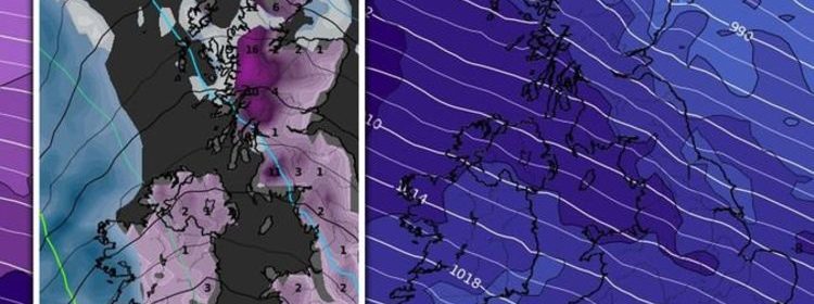
Maps and charts for the start of February see Britain covered in snow after a chaotic pressure system at the beginning of the month. Temperatures are set to plunge in the period, with the rest of January seeing colder conditions and a trend towards unsettled conditions.
According to WXCharts, a polar blast is set for early February where the mercury could plunge as low as -7C.
The agency holds snow is forecast for January 30, but is set to stay localised to Scotland, where 11cm is expected to fall over Inverness at 9pm.
From February 3 however, a band of rain pushes southeastwards from the Atlantic, striking the west of Scotland and Northern Ireland from midday.
By 6pm, 1cm of snow is set to fall in Scotland, with some south of Edinburgh, while 3mm of rain falls over Liverpool and Newcastle as well as the west of Scotland.
Temperatures are set to fall to -1C overnight, before conditions clear by the morning and lows of 2C are felt across Britain.

On February 4, snow and rain will stay localised in Scotland, but a pressure system in the Atlantic begins to build to the west.
This is set to strike from February 7, where Northern Ireland soaks except for Derry with 1cm of snow, and the west of Scotland sees 2cm of snowfall.
By midday, snowfall will be seen across Ireland, and will have struck much of Scotland and continue to fall in the west, while also pushing down through England and Wales.
Midday sees a band of 5mm an hour rain strike across London the south east, while a warmer front means the snowstorm turns Cornwall, central Wales and the midlands wet with 1mm rain.
A snowstorm is set to continue into February 9, where more Atlantic pressure brings 19cm of snow over Inverness and 3cm over Carlisle.
Snow is set to keep falling in most areas, barring the east and south of England, and central Wales, through to February 11.
Temperatures will bottom at -8C in Scotland on February 8 at midnight according to WXCharts.

The Met Office’s long-range forecast, covering the start of February, agrees weather will start off much more unsettled.
Covering January 30 to February 8, it said: “Through this period, the weather is likely to start off wetter than of late in the west, with patches of rain pushing northeastwards from the southwest on Sunday, whereas the east is likely to be settled and dry.
“Cloudy and dry weather is then possible to return for most at the end of January, while it is likely to be wet and windy in the north at times, with wintry showers possible over high ground in Scotland.
“Moving into February, the largely settled and cloudy weather is likely to remain for most, with some rain and wind in the far northwest at times.
“Overall, temperatures are likely to be near or milder than average through this period, although some brief colder than average spells in the north are possible.”


A Met Office spokesperson told Express.co.uk that hopes are low for snow to end January.
They said: “There is the possibility of some wintry conditions in the forecast, but confined mainly to high ground in the north of the UK as we would expect at this time of year.
“There’s no indication of widespread snow for the end of January.”
Tyler Roys, AccuWeather senior meteorologist and lead European forecaster, also told Express.co.uk that before the end of the month “the weather is going to be quite settled”.
DON’T MISS
Ian Blackford contiues desperate demand for Scottish independence [LATEST]
Prince Andrew’s self-entitlement exposed with ‘common people’ quip [ROYAL]
South China Sea: ‘Recovery ops!’ US navy race China to recover jet [INSIGHT]


Mr Ros said: “This will lead to widespread fog for England and Wales late Monday night and Tuesday morning. Fog will again develop across southern Wales, the Midlands and southern England Tuesday night and linger into Wednesday morning.
“The fog will be the most widespread across southern Wales into southwestern England. A cold front will move into northwestern Scotland on Wednesday with periods of rain.
“This cold front will move to the south-southeast across the United Kingdom Wednesday night into Thursday and bring showers to Northern Ireland, western half of England and Wales. The warmest day will be Thursday across the Midlands and southern England which temperatures will try to reach around 10C. This will be ahead of the cold front moving through.


“Behind this front, temperatures will go back to the mid to upper single digits across the country.
“Dry weather will settle across much of the United Kingdom by Thursday afternoon and continue into Friday. This will lead to another foggy morning across parts of Wales and southwestern England on Friday.
“The day that will likely feature the most sunshine of the week, is at this time to be Thursday.
“There is a risk for a cold front to move across the United Kingdom this weekend with the scattered rains, but confidence on this is low at this time.”
Source: Read Full Article
