UK snow forecast: Polar blast sees Britain hit by 5CM of snow in new BIG FREEZE – maps

BBC Weather: Freezing temperatures and fog forecast for UK
We use your sign-up to provide content in ways you’ve consented to and to improve our understanding of you. This may include adverts from us and 3rd parties based on our understanding. You can unsubscribe at any time. More info
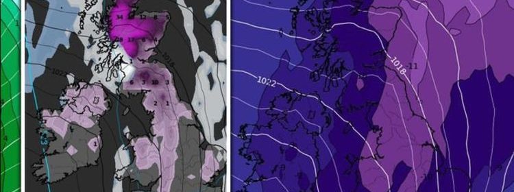
While much of January is set to see settled weather due to high pressure, maps and forecasts suggest the end of the month sees Britain buffeted by snow from a north-western weather front. Over the weekend, more fog and frost are also forecast for Britons, after a week of Met Office weather warnings.
According to WXCharts, the week starting January 24 sees conditions begin to worsen after high pressure dominates for most of the month.
Atlantic bands of rain are set to feature across the north east of Britain and Northern Ireland through to January 25,
However, from 6pm on Wednesday, charts hold lower pressure brings Atlantic weather fronts of rain and snow over all the UK.


From 6am on January 27, a band of snow will push south-west-wards from Scotland and begin to build up over the country.
Over the weekend leading up to the end of the month, snow will gradually move further down into England and Wales, with an expected 34cm of snow over the northern-most parts of Scotland on January 30.
Maps also hold the UK will have a 20 percent probability of snow falling on Sunday January 23, building throughout the week.
On January 24, charts show snow probability reaching between 50-60 percent in the Highlands of Scotland.


Commenting on the back end of the period of January 27, the Met Office states: “Later in the period there remains a possibility that low pressure could move east, bringing strong winds and cold wintry showers to windward coasts.”
In their forecast for January 28 to February 11, they added: “This period is likely to see a gradual transition to more unsettled conditions.
“Heaviest precipitation is likely to occur across the northwest, particularly later in the period, whilst drier than average conditions are more likely to prevail in the southeast, particularly earlier in the period.
“Spells of strong winds are likely, mainly in the north. Temperatures likely to be slightly above average overall.
“Some colder interludes are still expected though, bringing a risk of occasional snow, most likely over northern hills.”

Meanwhile, a yellow weather warning for fog is in place form 7pm on Friday January 14 to 11am on Saturday.
The Met Office said: “Fog patches will form this evening, becoming more widespread overnight.
“Some dense fog patches are possible, with visibilities perhaps dropping to between 50 and 100 m in a few places.
“Conditions should slowly improve on Saturday, although a few areas of fog may last until afternoon across the east of the warning area.”
The warning affects the following areas:
- East Midlands: Derby; Derbyshire; Leicester; Leicestershire; Lincolnshire; Northamptonshire; Nottingham; Nottinghamshire; Rutland
- East of England: Bedford; Cambridgeshire; Norfolk; Peterborough; Suffolk
- North East England: Darlington; Durham; Stockton-on-Tees
- North West England: Cheshire East; Cheshire West and Chester
- South West England: Gloucestershire
- Wales: Wrexham
- West Midlands: Herefordshire; Shropshire; Staffordshire; Telford and Wrekin; Warwickshire; West Midlands Conurbation; Worcestershire
- Yorkshire & Humber: East Riding of Yorkshire; Kingston upon Hull; North Lincolnshire; North Yorkshire; South Yorkshire; West Yorkshire; York

Paul Michaelwaite, Netweather.tv director, also said on the agency’s website: “The first change will be later today (Friday), when there’ll be more fog and low cloud through eastern and perhaps also central England from this evening and overnight.
“A good deal of that is likely to hang around throughout the day on Saturday as well, so a much cooler, greyer day for some.
“On top of that, more cloud will tend to drift in from the west across the country as the day wears on, with the best of the sunshine likely to be in eastern Scotland and across a good deal of Northern England as well.
“Then, on Sunday we’ll actually have a weather front arriving onto the scene, moving around the top of the high pressure and down from the northwest.
“It’ll have some rain along it as it moves through Scotland overnight Saturday and into the start of Sunday.
“But, as it moves further south it’ll be having the life squeezed out of it, so for England and Wales it’ll be not much more than a band of cloud with some patchy, mostly light rain here and there.”
Source: Read Full Article
